As Detroit became the Arsenal of Democracy in 1940, a serious housing problem arose. Thousands and thousands of men and women were recruited to work in defense plants but there was no place for them to live. Very few homes or apartments were built during the 1930s so the first strategy was to utilize existing structures. Many of the older homes throughout Detroit, including some elegant Victorian mansions, were subdivided to create small places for defense workers. A linked challenge was the great increase in employment at the huge Willow Run plant that was quickly erected to build B-24 Liberator heavy bombers. By 1945, that factory, run by Ford, built 7,000 bombers and component parts for an additional 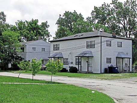 1900 bombers that were assembled in other factories. The Willow Run plant, designed by Albert Kahn, contained 3.5 million square feet of space, opened in October, 1941 and was almost 35 miles west of Detroit in Ypsilanti. The federal government built very many temporary housing units near the Willow Run plant. Quonset huts, I believe, were used for this housing which was torn down shortly after the end of World War II. In addition, the government quickly built an expressway to allow workers to get there from Detroit. Slightly rebuilt, this is now known as I-94.
The federal government’s National Housing Agency had funds available to construct homes for defense workers. This was not as easy to accomplish as you might assume. Very many elected officials and local leaders contended that housing for defense workers was certainly needed but should be built in some other community, not theirs. They knew that the homes would be constructed rapidly using whatever materials might be available. They also recognized that blacks coming to Detroit to build tanks, jeep and engines for planes and boats faced an even much more severe housing challenge than whites since they were confined to the neighborhoods in Detroit that strictly enforced Jim Crow policies assigned to African-Americans. The first major racial confrontation during World War II involved the Sojourner Truth housing project built in Detroit. For about two months in early 1942, organized groups of whites prevented blacks from entering; a blockade that was ended with a major use of police and military staff. Dearborn Mayor Orville Hubbard began to develop his reputation as the nation’s leading advocate of keeping blacks out of the suburban ring by staunchly and successfully opposing the federal government’s efforts to build housing for defense workers in his community.
The area where the Norwayne project was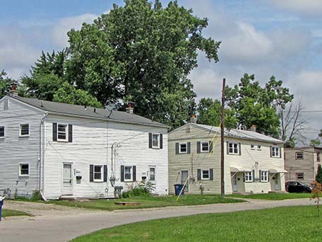 constructed was more or less vacant in the early 1940s and this may have muted opposition. At that time, it was within Nankin Township. In 1829, the territorial legislature in Detroit chartered two townships in western Wayne County: Lima and Richmond. The federal postal service had some control over the titling of communities at that time since they did not want two post offices in a state to have the identical names. Apparently Lima and Richmond had been used in Michigan territory. Someone, perhaps having fun, decided the new townships should be called Nankin and Pekin after the cities in China. There was little chance than any other Michigan settlement would ever select those names. By 1960, Nankin Township had a population of 60,000, apparently making it the largest township in the country.
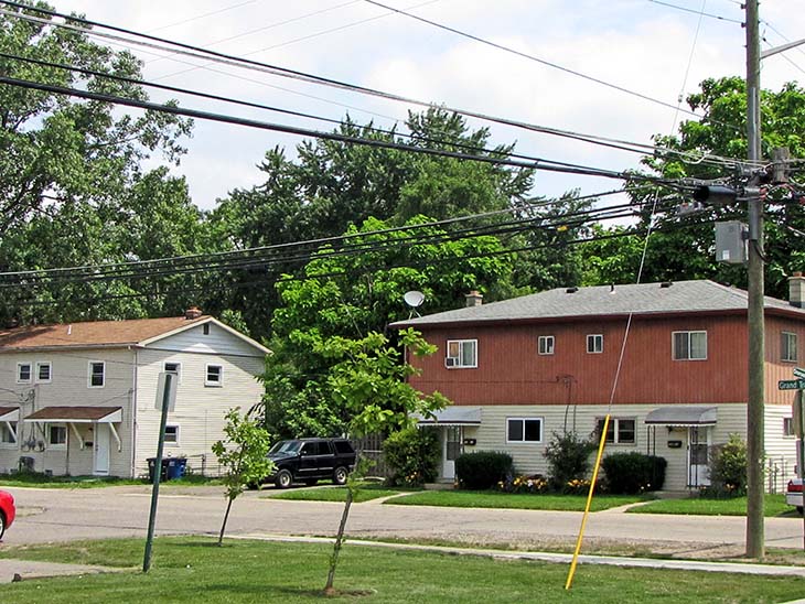
Construction at Norwayne began in 1942 and was substantially completed the next year, although the community church was not finished until 1947. The project included 1,189 residential buildings with a total of 1,870 residential units. It included:
192 one bedroom row houses
200 two bedroom row houses
362 two bedroom twin homes
644 two bedroom single family homes
472 three bedroom twin homes
2 elementary schools
1 community center
1 fire station
1 community church
A very modest strip mall shopping area of ten small stores at the corner of South Venoy Road and Dorsey.
Given that the defense industries had priority for most all goods, the architects and builders had to cope with a shortage of supplies. For instance, when constructed these structures had no gutters. The lot sizes were also very modest.
The government apparently believed that housing needs were greatest for lowly-paid defense workers. Residential units in Norwayne were rented, during the war, only to couples with earnings of less than $2,000 per year and $2,400 for a family of four. Preference was given to defense workers, military personnel and veterans. Attention was paid to the physical layout of 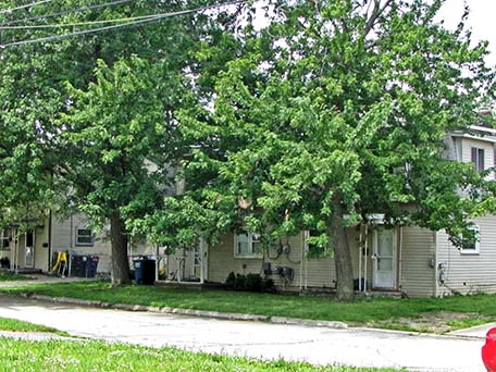 the community. Rather than using a rectangular pattern, most of the streets are curved with numerous cul-de-sacs. Many of the streets are named for Michigan counties. The documentation provided to the National Park Service for listing this community as a National Register Historic site asserts that in 1945, five thousand families lived here with a total population of 20,000. These numbers seem far too large. Doubling up in residences was common during and after World War II but it is challenging to believe that the 1870 residential units provided housing for five thousand families.
The federal government built and managed this community, including providing water and sewerage service. In 1948, administration was turned over to Nankin Township. By 1953, the government was selling the Norwayne homes with a preference for military veterans. However, the district did not fare particularly well. The homes were, in many ways, considerably less appealing that the homes that were being constructed in the western Wayne County suburbs in the 1950s. Quite a few of the Norwayne homes deteriorated and were eventually razed. Apparently, some other residents in nearby suburbs used the term “Shackville” to refer to this deteriorating community.
In the early 1960s, the neighboring suburb of Livonia sought to annex the revenue-generating part of Nankin Township where the Westland Shopping Mall was under construction. I believe that Livonia did not want to annex the Norwayne District. The residents of Nankin Township successfully fought that annexation but then, in reaction to that annexation threat, decided to incorporate their area to become the city of Westland which is now the tenth largest city in the Michigan with an estimated population of 82,000 in 2014.
The economic recession of 2008 led Congress and the federal government to adopt Keynesian policies to stimulate economic growth. A Neighborhood Stabilization program was funded to provide support to communities that were hard hit by the numerous foreclosures of homes attributable to the recession and the sub-prime lending scandal. The city of Westland received $2.1 million in 2009 to improve the Norwayne District.
The two elementary schools in this community were closed and, by 2015, were scheduled to be demolished. The original firehouse was torn down and replaced. Funds were used to replace sidewalks and improve the Community Center. The Norwayne Community Church was in existence in 2015 and a few stores were open in the small shopping strip at the intersection of Dorsey and South Venoy. When this district was listed on the National Register, 1124 of the original 1189 residential units—95 percent—were still in existence.
The National Park Service report whose url is shown below provides a very extensive history of Norwayne and a listed of all of the structures located there.
Architects: Maynard Lyndon and Eberle M. Smith
Augustus O’Dell, Thomas H. Hewlett and Owen A. Luckenbach
Date of completion: 1943 for most structures
Use in 2015: Residential neighborhood
State of Michigan Registry of Historic Sites: Not listed
National Register of Historic Places: #13000479; Listed July 9, 2013
National Park Service document about this historic resource: http://www.nps.gov/nr/feature/places/pdfs/13000479.pdf
Photograph: Ren Farley
Description prepared: July, 2015
Return to Multi-Unit Housing
Return to National Historic Districts
Return to Homepage