Congress enacted legislation on January 11, 1805 making Michigan a separate territory effective June 30 of that year. Prior to that time, Michigan was administered as part of Indiana territory. Frankly, there was not much administration to be done in Michigan since the only two settlements of Europeans were the small numbers of French who clustered around Detroit and the Straits of Mackinac. President Jefferson strongly promoted the development of the West, so he appointed men to territorial offices who, he hoped, would devote themselves to the tasks at hand. A former Revolutionary War general, William Hull was appointed territorial governor and Augustus Woodward was appointed the first federal judge for Michigan territory. Hull successfully negotiated treaties to obtain much land from Indians that could eventually be used by settlers. Woodward devoted his efforts for years to create a metropolis in the wilderness at Detroit.
It was extremely difficult to get to Detroit from the east since a huge, roadless swamp surrounded what we know today as Toledo. Coming from the East, you had to travel to a port on Lake Erie and then sail to either of the southern ports in Michigan: Monroe or Detroit. Judge Woodward managed to arrive in Monroe in May, 1805 just before a fire—on June 11—burned almost every building in the Francophone village of Detroit. The population was small. The federal census of 1810 counted only 4,700 in all of Michigan. About 2,300 of those lived in what was called the Detroit district, an area that extended from, roughly, present-day St. Clair Shores to Monroe. Scholars who write about the War of 1812 estimate Detroit’s population at about 800 at the time of its surrender to the British in August of that year. That was probably the size of the town that was burned to the ground.
Upon arrival in Detroit, Woodward assisted Father Gabriel Richard in trying to find food and supplies for the homeless residents. A small number of French settlers lived along the tributaries of the Detroit River on both sides of the border. Presumably, they provided assistance.
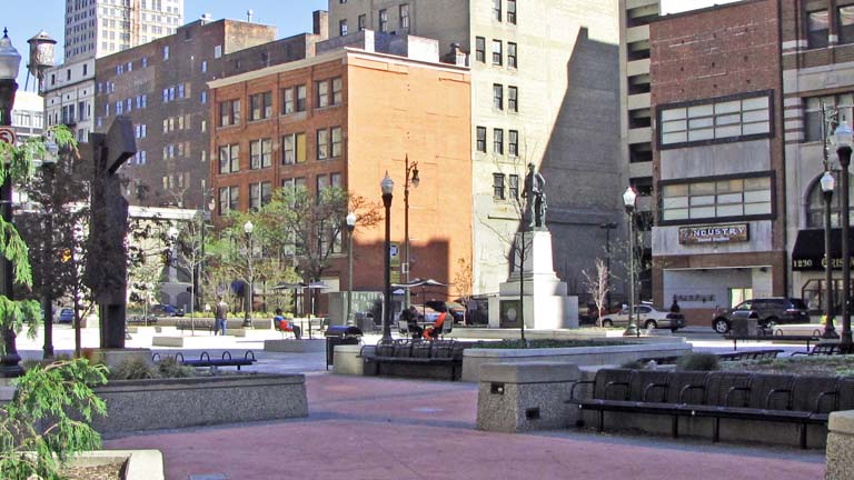
The Greeks and Romans constructed magnificent public buildings but paid much less attention to the design of cities. Presumably, most cities grew slowly and by the time officials considered what would be the ideal structure for the place, the city was already plotted and very little could be done to change the long-standing patterns of land use. Judge Woodward saw an opportunity in the catastrophic Detroit fire. Modern city planning developed in France in the 1700s, and in that era, the French designers were assumed to be the most accomplished at laying out a city. Washington was to be a new city created in the wilderness. President Jefferson desired an elegant city so he recruited Pierre L’Enfant to lay out the distinct but uniquely challenging patterns of streets we now have in the nation’s capital. Judge Woodward borrowed from L’Enfant to design a new Detroit. That is why five radials lead away from central Detroit and why Campus Martius and Grand Circus Park are where we find them today. The street pattern Woodward imposed led to some unusually shaped areas including what is now Capitol Park.
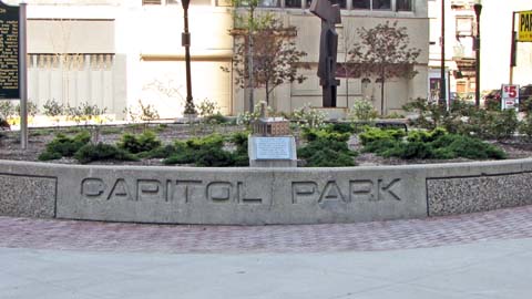
Michigan’s population grew slowly and the state remained isolated for more than a decade after the end of the War of 1812. Finally, the territory’s officials decided to build a capitol. They choose the park you see pictured above. The cornerstone was laid in 1823 and on May 5, 1828, the territorial government moved into the building. It also housed the territorial courts. Designed by Obed Wait, who must have been influenced by Jefferson’s ideas that governmental building should incorporate classical design, it was among the first Greek revival style buildings constructed in the state. It was a two-story red brick structure with a very traditional Ionic portico and an immense 140-foot tower. It served as the territory’s capital through the early years of statehood. A model of that fine capitol is on display in the recently renovated Capitol Park. The state’s first constitution—written in 1835—specified that the capital could remain in Detroit for 12 years, but would then have to be located elsewhere. After much political bickering, the legislature awarded the capitol to a rural site that developed into Lansing. On March 17, 1847, the building’s use as a capitol came to an end. The city’s schools purchased the building in the 1850s and by the next decade it was being used as Detroit’s secondary school and library. Four classrooms were at to the rear of the former capitol. It was then used as a secondary school until it was consumed by fire on January 27, 1893. At that time, construction was underway on the massive new high school that is known as Old Main on the Wayne campus today.
As Detroit grew to become a large and prosperous city in the late decades of Nineteenth Century and the early decades of the next, architecturally significant and very substantial buildings surrounded the park. There is a list below of those included in this website. In 1955, city officials decided that Capitol Park should become a major junction point for buses going to almost all points in the city. Traveling from the east side to the west side, you might change buses at Capitol Park. That worked for some time but as bus patronage declined and the buildings emptied in the 1970s, desirable features of the park disappeared. There often seemed to be many unsavory characters and unusual people in the area. City officials knew that it would be wise to make changes. A major new downtown bus junction point was established at the nearby Rosa Parks Transit Center. And then, in 2009, a major 1.1 million dollar renovation of Capitol Park was undertaken. The Kresge Foundation, the city of Detroit and the Downtown Development Authority contributed to renovating the park. This included moving the statue of Governor Stevens Thomson Mason, repositioning the Sentinel X sculpture, placing some attractive low-rise structures in the park and other changes. On October 27, 2011, the new Capitol Park was formally dedicated with the reinternment of the remains of Stevens Mason at this site.
By 2012, there appears to be reason to be hopeful about the future of this small area of Detroit. The once-idle David Stott Tower is undergoing renovation. A bar has opened there on the ground floor and another will soon open on the 33rd floor offering dramatic views. Commercial space will be available soon. The Downtown Development group has approved funding for the renovation of both the Farwell Building and the Detroit Savings Bank Building.
This website provides information about the following buildings at Capitol Park:
Detroit Savings Bank/Chamber of Commerce Building — Frederick Spier and William Rohns, 1895
Farwell Building — Harrie Bonnah, 1915
Griswold Building — Albert Kahn, 1929
David Stott Building — John Donaldson, 1929
Historical markers at Capitol Park include:
One commemorating Stevens Thompson Mason and the founding of the state of Michigan
Finney’s Barn and the Underground Railroad in pre-Civil War Detroit
Union High School
Website for Capitol Park: http://detroitcapitolpark.com/
City of Detroit Designated Historic District
State of Michigan Registry of Historic Sites: Capitol Park is within the slightly larger Capitol Park Historic District, P35753.
National Registry of Historic Places: Capitol Park is within the slightly more encompassing Capitol Park Historic
District; #99000338,
March 18, 1999
Photographs: April 20, 2012
Description updated: February, 2013
Return to City of Detroit Historic Designations
Return to Federal Register of Historic Districts
Return to Michigan Registered Historic Districts